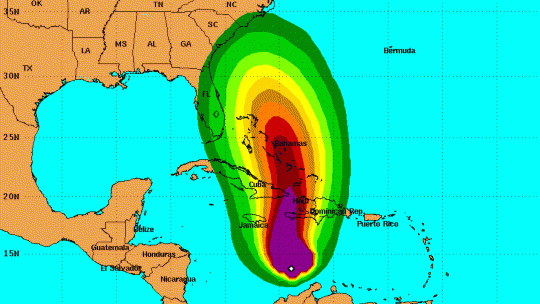
The Miami based National Hurricane Centre in its latest release says at 8am on Sunday, the center of Hurricane Matthew was located near latitude 14.1 North, longitude 74.3 West.
Matthew is moving toward the northwest near 5 mph (7 km/h).
This general motion is expected to continue today, followed by a turn toward the north tonight.
On the forecast track, the center of Matthew will approach southwestern Haiti and Jamaica on Monday.

Maximum sustained winds are near 150 mph (240 km/h) with higher gusts.
Matthew is a category 4 hurricane on the Saffir-Simpson Hurricane Wind Scale.
Some fluctuations in intensity are possible during the next couple of days, but Matthew is expected to remain a powerful hurricane through Monday night.
Hurricane-force winds extend outward up to 25 miles (35 km) from the center, and tropical-storm-force winds extend outward up to 205 miles (335 km).
The minimum central pressure reported by an Air Force Reserve Hurricane Hunter aircraft is 947 mb (27.96 inches).
Hurricane conditions
Hurricane conditions are expected to reach Jamaica and Haiti on Monday, and eastern Cuba Monday night.
Tropical storm conditions
Tropical storm conditions are expected to first reach Jamaica and Haiti this evening, and eastern Cuba early Monday, making outside preparations difficult or dangerous.
Preparations to protect life and property should be rushed to completion.
Tropical storm conditions are expected along the southern coast of the Dominican Republic within the warning area by tonight.
Hurricane conditions are possible in the hurricane watch areas by late Tuesday with tropical storm conditions possible by early Tuesday.
Tropical storm conditions are also possible in the tropical storm watch area in the Dominican Republic by late Monday.
Matthew is expected to produce total rain accumulations of 15 to 25 inches over southern Haiti, with possible isolated maximum amounts of 40 inches.
Matthew is expected to produce total rain accumulations of 10 to 20 inches over eastern Jamaica, the Dominican Republic and eastern Cuba, with possible isolated maximum amounts of 25 inches.
This rainfall will produce life-threatening flash floods and mud slides.
Matthew is expected to produce additional rain accumulations of 1 to 2 inches over Aruba, Curacao, and Bonaire through today. Matthew is expected to produce total rain accumulations of 2 to 4 inches over northern Colombia, northwest Venezuela, and western Jamaica, with possible isolated maximum amounts of 6 inches.


.jpg)


 All feeds