
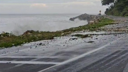
Storm surge in Roselle, St. Thomas early Wednesday morning, already causing damage to the road surface along the Southern Coastal Highway
.png)
Evan Thompson, Principal Director, Meteorological Service of Jamaica
Principal Director of the Meteorological Service of Jamaica Evan Thompson is expressing concern about storm surge from Hurricane Beryl.
Mr Thompson, speaking Tuesday on Radio Jamaica's Beyond the Headlines, described that movement as one that would see surge "pushing onto the shoreline, moving onto the coastal areas."
Elaborating, he explained that with such movements, "the water comes in from the sea, but (then) pulls back into the sea, and at that point it pulls a lot of things with it; it could mean buildings, it could mean other infrastructural works that are along the coastline.
The projection is for storm surges to result in water levels rising by as much as 2-3 metres or (6 to 9 feet).
The centre of the hurricane is expected to be passing near or over the island's southern coastline between 10:a.m., and 8:00 p.m., Wednesday.
Latest bulletin from the National Met Service
At 4:00 a.m. (Wednesday) the eye of Hurricane Beryl was located near latitude 16.6 degrees North,
longitude 74.4 degrees West. This is about 240km (150miles) east-southeast of Morant Point,
or 300 km (185 miles) east-southeast of Kingston, Jamaica.
Beryl is moving toward the west-northwest near 31 km/h (20 mph) and this general motion
should continue through today, followed by a turn more toward the west tonight or Thursday.
Maximum sustained winds have decreased slightly to near 230 km/h (145 mph), with higher gusts;
hence, Beryl remains a Category 4 hurricane on the Saffir-Simpson Hurricane Wind Scale.
Some weakening is forecast during the next day or two; however, Beryl is forecast to be at
or near major hurricane intensity when it reaches Jamaica later today and the Cayman Islands
tonight or early Thursday.
Hurricane-force winds extend outward up to 75 km (45 miles) from the centre and tropical-storm-force winds extend outward up to 295 km (185 miles).
The eye of Hurricane Beryl is expected to continue past southwestern Haiti and move quickly
towards the southeastern coast of Jamaica this morning. On this forecast track, the centre of
the hurricane is expected to be passing near or over the island’s southern coastline between
10:00 a.m. and 8:00 p.m. today.
Rainfall from the outer bands of Beryl have already been affecting sections of Jamaica.
Rainfall associated with the core of the hurricane should, however, start to impact the eastern
end of the island within the next 3-4 hours. Rainfall totals of 100-200 millimetres (4-8 inches)
are forecast for most areas over the period, with higher amounts in higher elevations.
Strong winds, reaching near tropical storm force, are expected to reach Jamaica as early as
9:00 this morning. These will quickly increase to near hurricane strength as the centre of
Beryl remains close to the island throughout the day.
Dangerous storm surges raising water levels by as much as 2-3 metres (6-9 feet) and battering
waves, will also be generated along coastal areas of the island.
The Meteorological Service continues to monitor the progress of Hurricane Beryl and all
interests are encouraged to pay special attention to further Releases.
The next Bulletin on this system will be issued at 8:00 a.m. today.
US National Hurricane Center
The US National Hurricane Center has also said that Hurricane Beryl is expected to "bring hurricane conditions to Jamaica by midday today with life-threatening winds and storm surge..."
comments powered by Disqus




.jpg)


 All feeds


