.png)
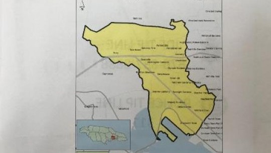
Prime Minister Andrew Holness announced a short while ago that a State of Emergency had been imposed in the St. Andrew South police division in the Corporate Area.
The Prime Minister, speaking at a press conference at Jamaica House, disclosed that from January 1 to June 29, this year there had been 94 murders in the division, as against 79 killings over the corresponding period last year.
A State of Emergency was imposed in a section of the same police division for a period last year, causing Opposition Leader Dr. Peter Phillips, in his response on Sunday afternoon, is accusing the government of having "only two speeds, as far as crime control operates - either it does very little, or it introduces a State of Public Emergency."
Police Commissioner Major-General Antony Anderson, in the now familiar wording of the declaration of a State of Public Emergency, said the high level of violent crime in the police division, particularly over the last two months, "is at a scale, and of a nature, that it greatly endangers public safety."
In April another State of Emergency was imposed in three western Jamaica parishes - Westmoreland, Hanover, and St. James.
The Prime Minister, in his analysis of the crime situation in Jamaica, made comparisons between this country's murder rate and that of the United States in 1962 (when Jamaica gained political independence) and how the two countries diverged over ensuing decades, with the US retaining a very low single-digit rate of murders per thousand of population, while Jamaica's has risen dramatically to 47.2 per 100,000.
The global average is is around six per hundred-thousand, while the average for the Caribbean and Latin American region - is 16 per 100,000, he said.
Against that background, he said the Jamaican situation was "not safe".
"This is an epidemic, and there's no one who can tell me that the country should be satisfied with this and not be prepared to take extraordinary measures to address this problem," he declared.
Below are the boundaries of the State of Emergency
East. Starting at the foot of Red Hills at the intersection of Perkins Boulevard, Molynes Road and Red Hills Road, extending in a south-southeasterly direction along Molynes Road, Seaward Drive, Mimosa Road, Aloe Avenue, Bay Farm Road, Newark Avenue, Elm Crescent, Keesing Avenue, Hagley Park Road, Omara Road, and Chisholm Avenue to the point of intersection with Maxfield Avenue.
South. Extending in a south-westerly direction from the intersection of Chisholm Avenue and Maxfield Avenue, along Maxfield Avenue onto East Avenue to the coastline in the vicinity of Petrojam and extending along the said coastline in the vicinity of the Kingston Container Terminal to the Portmore Causeway Bridge.
West. Continuing in a north-westerly direction from the Portmore Causeway Bridge along the Fresh River, the shared parish border of St. Andrew and St. Catherine west of Riverton, and extending to the vicinity of the western most end of the Belvedere to the Ferry secondary road.
North. Extending in an easterly direction along the Belvedere to Ferry road to the foot of Red Hills at the intersection of Perkins Boulevard, Molynes Road and Red Hills Road, the start point.


 All feeds


